
County parcel data does not come with zoning rules
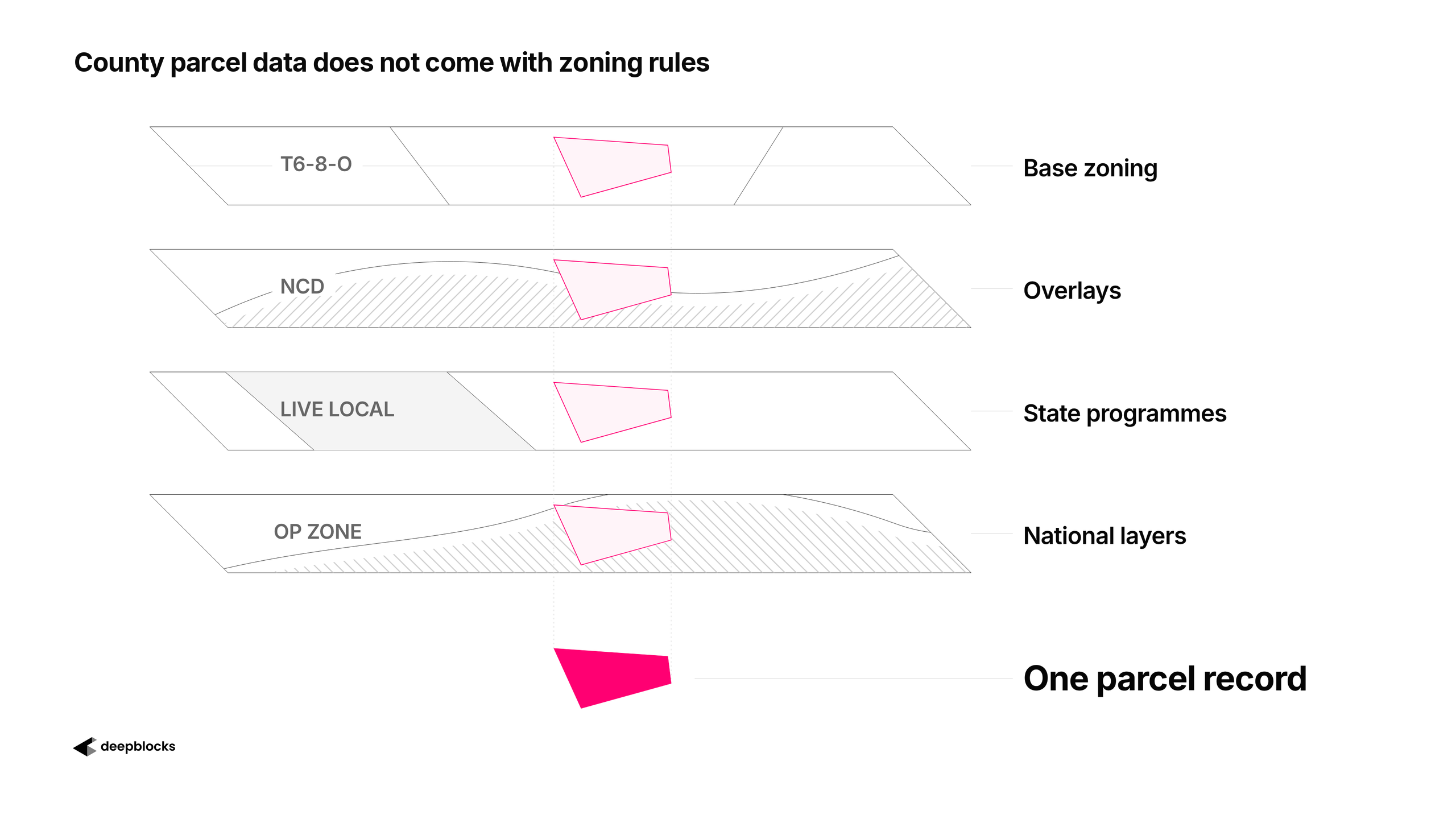
When you get parcel data from the county, it tells you what is on the land today. It does not come with the layers of rules that decide what the land could become: the zoning district, the overlays, the state programmes, the federal designations. Those have to be found elsewhere and built onto every parcel, one layer at a time.
Explore DEV to prove if a site pencils: Drop a pin, model in 3D, and watch returns move.
What the County Gets Right
The county is not the problem. The county gets its part right, and its part is large.
The property appraiser knows what stands on every lot: the building, its size, its year, its use. The county knows who owns the parcel, what they paid and when. It knows the land use, the assessed value and the lot's exact boundary. Tons of data, and it is the foundation of everything else.
What the county does not know is what could be built there, because zoning is not the county's job. Zoning belongs to the municipality, and a single county can hold dozens of them, each with its own ordinance, its own districts and its own logic. Standardising zoning across all of them is not a data field. It is an entire business venture, and it is the one we chose at Deepblocks.
The District Name Is One Step
Some counties do include the zoning district name for each parcel. That is a real convenience. A person on the assessor's website can read that a lot is T6-8-L without finding a zoning map and working out which polygon the lot sits in.
But the district name is only a pointer. To learn what T6-8-L allows, you open the city's zoning ordinance, find the district, and read: how many units per acre, how tall, how much floor area, how far from the street, which uses.
The ordinance is text, not data. Data can be downloaded, joined and filtered by a programme. Text has to be read, and what it says has to be interpreted into numbers before any software can use it. No two cities write their ordinances the same way, so the interpretation starts over with every city.
For most of Deepblocks' history that interpretation was human work. It is the work our real estate harness now does, and later posts show how.
And the zoning district name is only the first layer of rules on a parcel.
Four Layers on One Parcel
Take 316 NW 11 ST in Miami, a small lot in Overtown. Four separate rule systems reach it, and each one was written by a different level of government for a different purpose.
Base zoning. The lot is in T6-8-L, a Miami 21 district. The district sets the starting rules: density, height, buildable area, setbacks, uses.
An overlay. The lot also sits inside the Southeast Overtown density increase area. An overlay is how a city changes the rules in one place without rewriting the district everywhere. Miami wanted more density in this part of Overtown. It did not want more density in every T6-8-L lot across the city, so it drew a boundary and raised the limit inside it. Elsewhere, T6-8-L stays as it is.
A state programme. Florida's Live Local Act reaches the lot from Tallahassee. If the majority of the units are affordable housing, Live Local overrides the local zoning and allows the maximum density the city permits anywhere. The city did not write this rule.
A national designation. The lot is inside a federal Opportunity Zone. This layer says nothing about what can be built. It changes the tax treatment of the investment, to encourage development in designated areas. It changes the returns, not what you can build.
Four layers, four authors, four purposes. The county parcel record carries none of them. It tells you the lot is 7,187 square feet and who owns it.
Building the Layers Onto the Parcel
Every one of those layers has to be spatially joined to the parcel, and joined in a way that keeps the relationships between them.
The base district comes from a spatial join: lay the zoning map over the parcel boundaries and record which district each lot falls in. The overlay is a second boundary, laid over the same parcels, and the record has to say that this overlay modifies the parcels beneath it, overriding the base district, not that two unrelated labels happen to apply. Live Local is a third layer, with a condition attached. The Opportunity Zone is a fourth, and it belongs in a different column altogether, because it changes the money and not the building.
If the record flattens all four into one list of tags, the relationships are lost. Nobody can tell which rule sits on top of which, or which one applies only under a condition. If the record keeps them as layers, with the base underneath, the overrides on top and the tax designation beside them, a person can read it the way a planner would.
This is the part we left out at first. When we digitised our first cities, we recorded base zoning and stopped, because base zoning alone took weeks per municipality. Overlays and state programmes came later, one layer at a time, and each one had to be found in its own source and mapped onto every parcel it touched.
Two Records, One Parcel
The county's record and the zoning record describe the same piece of land, and they answer different questions.
Parcel data tells you what exists. Zoning tells you what is possible.
The county gives you the first. The second has to be built, layer by layer, onto every parcel in the city.
Explore DEV to prove if a site pencils: Drop a pin, model in 3D, and watch returns move.